Herculaneum
G.I.S. Geo-referenced territorial platform
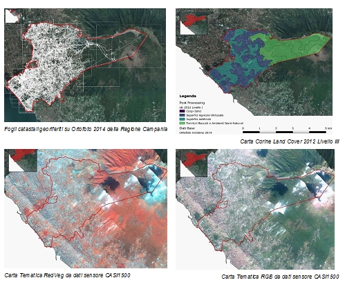
Implementation and data processing for the government and protection of the territory of Herculaneum on the Georeferenced territorial platform in the G.I.S. environment: land and buildings registers; Fires report from 2007 to 2016 of the municipality of Herculaneum; National Plan of Vesuvius; Environmental and urban planning constraints; Fire-register classification on hyperspectral RGB image of the CASI 1500 sensor
The Benecon Research Center has created, on behalf of the Municipality of Herculaneum, a technological tool for the management and governance of the natural and built territory, with reference to the urban planning and sector planning tools made available by the technical office of the Minicipatily. These data were integrated with new quantitative and qualitative spatial data, produced by Benecon, through a remote sensing campaign conducted with the ITRES CASI-1500 hyperspectral sensor and with a very high resolution photographic camera. A G.I.S. platform has developed (Geographic Information System), which makes it possible to make the data homogeneous, georeferenced and manageable in an integrated, questionable and implementable over time, making the research activity aimed at managing the territory and future planning.